Capacitor Peak Update
FS6801 Rd is not obscure to find and clear of windfall until about 1 mi. in. Directions to FS6801 are available by other blog entries. Going east on FS60, if you get to the PCT, you've gone too far.
What will become a theme with these summits in the Mountain Lakes Wilderness, is that there isn't really a trail to the top. I elected to get to the top by following the ridge which leads, almost in a crescent shape, to the summit from the Clover creek trailhead. I feel as far as distance/ease of travel this is the best route. See the image below.
Compared to nearby Mount Carmine, getting to the trailhead of this one is a breeze. I parked at the Varney Creek trailhead off of Highway 140. The road is well signed and in good shape with plenty of parking. This summit though, at least the way I went, uses absolutely zero official trail. From the parking lot I headed south along what looked to be an old logging road that has since been overgrown It didn't take long for that to fade away then you are left with open forest to find your way. The lower part of this route had been logged previously which mad
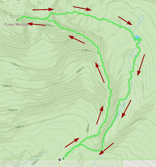
Fair warning, this one is a bit of a tricky one. This summit doesn't have a trail to the top at all. You could possibly access it from the Mountain lakes loop trail but it would be a very steep scramble over loose rock, it looked a bit too dicy to me when I did my scouting hike around the loop a few months earlier. I elected, instead, to use part of the old moss creek trail which was abandonded by the forest service but is still maintained by individuals. The old moss creek trailhead is located on land owned by green diamond and is only open to vehicle traffic
From memory 2 years late... mainly you need to know the area is gated most of the year, opening around hunting season, I think September to November. This summit was basically a drive up summit, at least to the AZ. Did it the same day as Indian Springs. Below is my driving route so I can find the right path again. I'll take better notes next time but hard to time these summits right with the Green Diamond gates.
de AG7GP
Trying this summary two years later from memory...
Most important thing is that Green Diamond only opens their gates certain times of the year. These roads aren't open off Clover creek rd until about hunting season, I think September. I don't know exactly when they re-close but around November 1.
I can't believe I missed reviewing McDonald in the past. I love McDonald Peak. It is a beautiful stroll from RD 20 on a nice trail, great view, great flora in summer time. It was one peak I spent some time at in 2019 and realized SOTA was where I belonged in radio. Sitting in the flower covered slope enjoying the view. Easy set up among a mix of slopes and boulders.
I just noticed I never did summaries for some of my first summits especially if they had a previous review so with the 2022 campout coming soon I am trying to catch up on some. Mt Ashland is an easy, popular summit. Outstanding 360 view of NCA to CLNP rim to Josephine Co. Cool boulder stacks too. You can drive to the dome on the summit if you wish. Just go a little ways past the Mt Ashland campground and you will see the road on the right with a not so visible sign (it is on a tall post since it is used during deep snow).
I got on here to correct/ edit my previous blog but realized I never did a first! I've done Burton a few times and it isn't that significant in features. Just an easy stroll through the timber. Plenty of area to set up. A nice easy trek, shaded summit but no view. No established trail but the dead end road you can continue on by foot and there are other cleared out areas from logging roads many years ago. For some reason I get discombobulated easily coming down Burton and sometimes come to far left nearly missing the spur. If you are like me, keep a tracker going.