Goat Mountain: (1.1 miles, 1,100 ft)
A GPS (with land ownership) is recommended – to help stay on the unmarked public land.
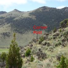
Take the Moose Creek Exit (Exit-99) from I-15. Follow the Moose Creek road westbound & turn left at the “Maiden Rock” sign & follow this road down to the Maiden Rock Mine Interpretive area just before crossing the river. Park here & walk NE up the hill, through the gate in the barbed wire fence. Angle upwards & to the right – with the objective of getting onto the right side of the north-trending ridge. The ridge crest (and areas to the left) are private property. The private property corner is on the side-hill & marked with an old wooden post. After rounding the post, head towards the right side of the summit. It is easier to stay on public land after this – so long as you resist the temptation to head straight up the fall-line. After you cross the first gully/swale, there is an old (mostly down) barbed wire fence that runs straight up the hill (generally west-east), this is not a property boundary & is of no concern – cross it when convenient. To negotiate the cliffs, we angled to the right of the left-most obvious large rock outcrop, generally staying on the grassy slopes & chutes where possible. We eventually found a nice path that dead-ended at a small cave of sorts. From this point, we traversed northwards & eventually got on the ridge by bushwacking through heavy brush & scrambling up the various cliffy sections. Nothing was too scary – but it did require some care. We found a better way down – it was about 200-400 feet further north. This path had a steep (mostly grassy) chute, and very little in the way of cliffs. I will try to upload this 2nd path onto the GPS tracks. Once you get on the ridge crest – it is a simple bushwack through juniper and mountain mahogany to the summit.

