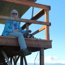
It was a beautiful day, all the way around. Kelly Butte is a great hike, a bit steep and exposed on the beginning switchbacks, but with wildflowers this time of year, and open views from the fire lookout.
Rainier filled the view to the south, and Seattle was visible through the foothills. Mt. Stuart, Glacier Peak and the "backside" of the southern Snoqualmie pass summits made a nice panorama.
The forest service roads are driveable even with a regular passenger car, just don't get going too fast, as there are some sharp bends, potholes to dodge, and some washboarding. My GPS led me right to the parking area, and there are also directions on the WTA web site: http://www.wta.org/go-hiking/hikes/kelly-butte
The old trail scrambled up the rocks, assisted by a rope. You can still take that route if you like that sort of thing, but I took the switchbacks of the new trail. It was hot and sunny - get an early start as there is very little shade.
After a series of switchbacks, the trail flattens out a bit in a grassy area, and then finally the lookout came into view. Two volunteers were spending the night there, and I explained SOTA to them. They seemed quite interested. Once again I brought my HT and a twinlead antenna for 2m FM operation. It took some time but eventually the contacts came. I moved my antenna up higher on the lookout than where the photo shows it.
There is room for various configurations of HF antennas near the lookout, and I look forward to operating HF from here in the future.

