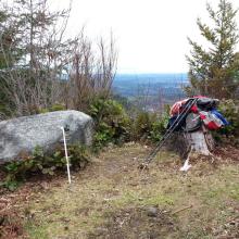
The Pack Forest is operated by the University of Washington, a bit south of Eatonville, Washington. www.packforest.org. Pack Forest High Point is not particularly well marked on the trail map and you may find that signage is a bit confusing, but it's a nice hike on a good forest road - about six miles round trip and 1100 feet elevation gain.
Directions to the Pack Forest can be found here: www.packforest.org/about/contact.shtml, or look for 9010 453rd St E, Eatonville, WA with your GPS. No pass is required for parking in the Pack Forest. Head up the hill to the parking lot and check in at ranger HQ (not well signed) for a map and directions. You may find this map more useful than the black and white one that is handed out by the ranger - www.packforest.org/education/11x17_low2.pdf. As always, don't be tempted to drive through any open gates - the Pack Forest is open only to hiking, plus horseback riding and mountain bikes on some roads, and may have seasonal closures for logging.
Head up 1000 Road South, walk past the Husky color gate - you'll shortly pass the Hugo Mountain Trail on the left that offers a shorter but steeper approach to Kirkland Pass. Be sure to head 'up' and not down at any unmarked intersection. It's two miles to Kirkland Pass where you'll find several roads leading off. Take the 2000 Road marked "Mile 3.1" another 1.1 miles to the summit. There's a short trail off the road to a memorial rock where you'll have clear views to the west. There's enough room for all but the largest antennas here, and if you like, there's a clearing just before the summit close to the road in the activation zone that may work well for HF antennas away from other hikers on the summit proper.
Pack Forest HP (Peak 2051), WA | February 2015
Summit
Trail Characteristics
APRS Coverage
Don't know
Cellular Provider
T-Mobile
Voice Cellular Coverage
Decent, workable
Data Cellular Coverage
Decent, workable


