UPDATE 2021 - Mount Lowe may have been damaged in the September 2020 fires. Check for access.
Mount Lowe is another former fire lookout sites in the Oregon Cascades - it's a short hike of about 3 miles round-trip and perhaps a net of 300 feet of gain. It has great views and good spots to operate.
Along with Mount Lowe you might consider a double activation of W7O/CN-052 - Oak Grove Butte or W7O/WV-009 - Bull of the Woods.
Mount Lowe is south of Estacada - accessed from Highway 224 and then FS-46 after the Ripplebrook Guard Station. Good directions can be found here - note that the trailhead coordinates are for the top of the jeep road, not the saddle.
https://www.oregonhikers.org/field_guide/Rho_Ridge_Northern_Trailhead
https://www.oregonhikers.org/field_guide/Mount_Lowe_Hike
The road is paved most of the way and can be navigated in a thoughtfully driven a passenger car. The only additional notes to consider is that the "jeep road" of 0.1 miles is behind you as you come up to the grassy spot at the saddle where you should park (near 44.974°, -121.976°), and that it's best to walk a short distance rather than drive that last bit of narrow jeep road.
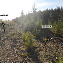
The trail is not marked here and is a bit obscure to start and can be found off to the right at the top of the jeep road. You can also continue up the described "rocky knoll" and go on into the woods after you drop down to find the trail. From here on the trail is obvious although not well-maintained.
There is a second trailhead starting from another road that you'll encounter after about one mile on the trail, this one has a trail sign (pictured). It may be possible to hike or even drive up this road for a shorter hike - but this 1.5 mile one way walk described here goes quickly and is easy enough.
Here's the former fire lookout: http://www.firelookout.com/or/lowe.html


