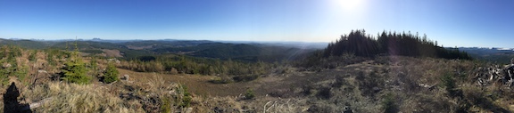
Easy Trail

Trail contains no technical obstacles

3537, WA | April, 2021

Submitted by K7AHR on
Summit

3537 is a 4-pointer right off Marble Mountain Sno-Park, and despite the busy climbing season it is easily possible to get in here and activate it. You might combine this with a summit of nearby LC-075, if you are feeling especially ambitious.

To get here, take I-5 to Woodland, then SR 503 which becomes SR-503 Spur, which turns into NF-90; turn left onto NF-83 and drive 6 miles to Marble Mountain Sno-Park.

Moose Ridge, ID| September, 2020

Submitted by AE7AP on
Summit

16.2 miles, +4,300 ft; -4,200 From Elk Mountain TH

1.2 miles, +300, - 200 ft ft from Trail 562 Junction

I activated this on the 14th day of a 15-day backpacking from the Elk Mountain Trailhead, via Mink Ridge & Marten Creek with a side-trip up Marten Creek to Marten Hot springs; but the route description is the more direct route across Goat Creek and along the Square Rock & Moose Ridge.

Shearer Peak, ID | September, 2020

Submitted by AE7AP on
Summit

18.5-miles, +4,700 ft; -5,300 From Elk Mountain TH

3.5 miles, +800, - 1,500 ft ft from Trail 562 Junction

I activated this on the 13th day of a 15-day backpacking from the Elk Mountain Trailhead, via Mink Ridge & Marten Creek with a side-trip up Marten Creek to Marten Hot springs; but the route description is the more direct route across Goat Creek and along the Square Rock & Moose Ridge.

Wylies Peak, ID | September, 2020

Submitted by AE7AP on
Summit

10.7-miles, +3,800 ft; -2,900 From Elk Mountain TH

1.2 miles, +1,000 ft from Trail 562 Junction

I activated this on the 12th day of a 15-day backpacking from the Elk Mountain Trailhead, via Mink Ridge & Marten Creek with a side-trip up Marten Creek to Marten Hot springs; but the route description is the more direct route across Goat Creek and along the Square Rock ridge that we took on our way out.

Vermillion Peak, ID | August, 2020

Submitted by AE7AP on
Summit

24.2 miles, +7,500 ft; - 6,800 From Elk Mountain TH

5.2 miles, +3,800; -500 ft from Buck Lake Creek

I activated this on the 7th day of a 15-day backpacking from the Elk Mountain Trailhead, but other approaches such as Meadow Creek or Indian Hill may also offer access.  We climbed from a camp in the beautiful Cedar-Hemlock forest alongside Buck Lake Creek.  While the forest is unburned upstream from the Disgrace Butte trail junction, the forest downstream was burned on the south side of the creek in a 2019 fire.

Disgrace Butte, ID | August, 2020

Submitted by AE7AP on
Summit

22-miles, +6,200 ft; - 6,500 From Elk Mountain TH

3.0 miles, +2,400 ft from Buck Lake Creek

I activated this on the 6th day of a 15-day backpacking from the Elk Mountain Trailhead, but other approaches such as Meadow Creek or Indian Hill may also offer access.  We climbed this from a camp in a beautiful Cedar-Hemlock forest alongside Buck Lake Creek.  While the forest is unburned upstream from the Disgrace Butte trail junction, the forest downstream was burned on the south side of the creek in a 2019 fire.

Horseshoe Lookout (6985), Idaho - 19July2018

Submitted by K7VK on
Summit

This summit is the old Horseshoe Lookout Site. It had a primitive platform on a rock pinnacle from 1921-1961. A standard L-4 structure, 1962-1983. Both structures succumbed to wildfires and were not rebuilt.  Concrete blocks from the L-4 lookout remain.  The access road, USFS #588 is 4 miles off FS #500. It is a good road and can be driven to the summit. I opted to use a bicycle the last 1.0 mile due to a steep and rocky appearing section.  You have already traveled #500 so this road will be no problem. Trees are available to hang antennas.

A quick trip up Highwire

Submitted by K7DDC on
Summit

After a bit of a hiatus, K7IAJ and I made a quick trip up highwire this afternoon. We wanted to make a quick trip up something that would be an easy objective. We originally chose Haystack Moutanin, but access was restricted, and the permitting wasn't clear: permits were listed as unavailable on the website/sold out, and they would be sold in April.

Peak 7407, MT | May, 2018

Submitted by AE7AP on
Summit

3.5-miles, +1160 ft; From Pipestone Pass TH

This is a pleasant hike along the Continental Divide Trail that begins near the summit of Pipestone Pass (paved, and plowed).  It is also a POTA “2-Fer” (Beaverhead-Deerlodge NF & CDT) if you activate within 100-feet of the CDT.  It is also located on the northern edge of the historic Thompson Park area, which is a unique congressionally designated Municipal Recreation Area that includes much history related to the Milwaukee Road (Railroad).